Morin Lake Reserve Implementation Tables
La Ronge – Morin Lake Reserve (Hall Lake) – Stanley Mission – Little Red – Sucker River – Grandmother’s Bay
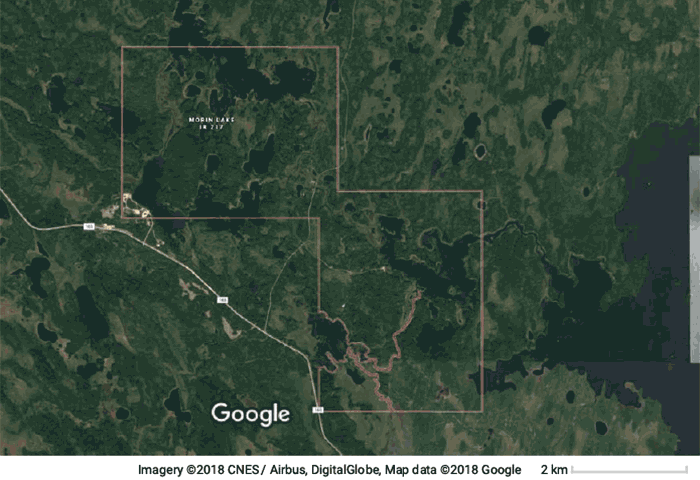
Location: 101 KM South-West of La Ronge.
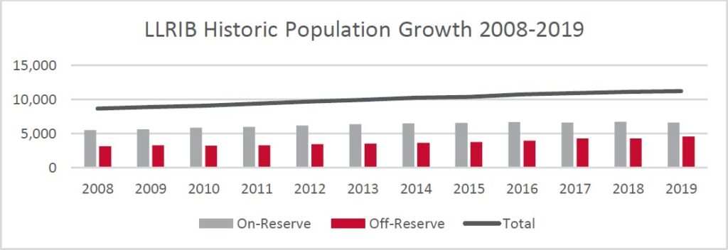
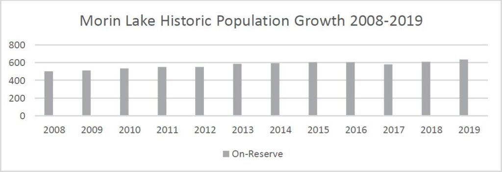
Population: 637
| Contact | Phone | Fax |
| Sub Office | 306 425 4797 | 306 425 4909 |
| Sally Ross School | 306 425 5041 | 306 425 5570 |
| Health | 306 425 8075 | 306 425 8091 |
| Daycare | 306 425 4089 | 306 425 4978 |
| Headstart | 306 425 4089 | 306 425 4978 |
Hall Lake is a part of Morin Lake Reserve 217 which includes Sikachu and Clam Lake Bridge. It was established as a reserve in 1968.
Culturally Significant Areas (excerpt CCBP, 2012).
Hall Lake is a sizable reserve with large areas of land that are not developed and have great value to the Band as culturally significant areas. Moreover, because of the logging that occurred in areas surrounding the reserve, the forested areas and lakes on-reserve are very important to Band members. Further, portage routes that connected water bodies and watercourses on-reserve were also identified. Band members also identified important areas for berry and mushroom picking that are culturally significant as well as the lakes where wild rice grows. The cultural areas on the map include berry patches, wild rice, portage routes and mushroom picking areas. All areas identified should be respected and preserved as the community develops in the future.
Hunting, fishing, trapping and foraging are important activities to many community members. They are important to the traditions and culture of Hall Lake and Sikachu, allowing for subsistence lifestyle over long periods of the year for some Band members. Also, the land provides economic opportunities in the form of wild rice within some of the lakes on the reserve. The vegetation, especially the forested areas on reserve are significant from a conservation and preservation perspective with much of the forested areas surrounding the reserve having been logged by logging companies. Lastly, it is important to recognize the importance of the land for recreation and cultural purposes, providing youth with an opportunity to learn about the history of their people through culture camps and other activities on the land. The map highlights areas that are important to these activities including important vegetated areas, wetlands, lakes and watercourses.
Google Maps – https://goo.gl/maps/Gmzesa7Nxp12
Downloads/News:
HALL LAKE COMMUNITY SAFETY MEETING – OCTOBER 16, 2018
Community Survey Response Summaries:
2019-05-01-ALL RESPONSES-Summary
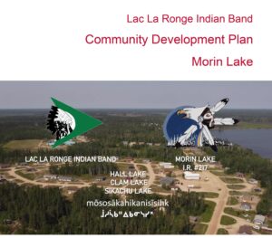
Community Development Plan
PDF Download – 2022-LLRIB-CCP-Morin-Lake
Acknowledgements
This Community Development Plan was developed with significant input from the members of the Lac La Ronge Indian Band (LLRIB) under the leadership of the Community Advisory Team (CAT). In the 2016-2017 fiscal year, the Executive Director applied for funding and began lobbying Indigenous Services Canada (ISC) to pursue funding for comprehensive community planning; funding was provided in December 2018. The project began with the recruitment of two Navigators, Leonard Roberts in La Ronge and Cora Ballantyne in Stanley Mission.
The CAT was appointed by Chief and Council, they began meeting and developing a plan of how to involve as many LLRIB members in community development planning as well as providing direction and support to the Navigators. The Advisory Committee members were as follows:
| Chair: | Gladys Christiansen | La Ronge |
| Co-Chair: | Gordon Hardlotte | Stanley Mission |
| Councillors: | Ann Ratt | La Ronge |
| Mike Bird | La Ronge | |
| Jimmy Charles | Stanley Mission | |
| Gerald McKenzie | Grandmother’s Bay | |
| Devin Bernatchez | Sucker River | |
| Norman Ross | Morin Lake | |
| John Halkett | Little Red |
I would also like to take this opportunity to thank the former members: Kenny Ratt (Sucker River), Angus Mirasty (Little Red), Larry Charles (Stanley Mission), they were instrumental in providing direction and feedback for this comprehensive community plan.
The LLRIB Chief & Council and management team (program directors) are involved in regular strategic planning, every 3-5 years the plan is updated. However, the last community planning took place in 2006. It was time to go back out to the communities to solicit their input and feedback as to what had been accomplished since the last community plan.
The Comprehensive Community Planning Initiative provides an opportunity for community members to have a voice in the community’s needs, goals and informs the leadership and management of the communities’ priorities.
The goals in the Comprehensive Community Plan are the results from the community feedback we received from LLRIB members, it is community based planning. What we heard from the community is that everyone wants a safe community, where families can feel safe in their homes and communities.
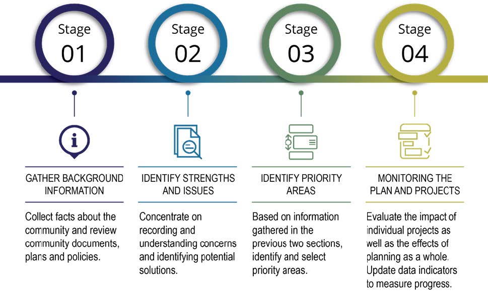
There are 4 stages to these plans, gathering information, identifying strengths and issues, identifying priority areas and lastly, implementing and monitoring the plan. Our job is to ensure that these plans do not sit on the shelf, that we are all working collaboratively towards these community goals. We all want safe communities for our children, grandchildren, and great grandchildren now and into the future.
Table of Contents
1 Introduction
1.1 Community Development Initiative
1.2 The Planning Process
1.3 Community Engagement
2 Community Profile
2.1 Community History
2.2 Demographics
2.3 2012 Community Plan – Actions Areas
2.4 Accomplishments
2.5 Strategic Planning
3 Community Goals
Governance
Land, Resources & Environment
Health
Education
Infrastructure / Public Works
Housing
Social
Economy
4 Community Action
4.1 How to Use This Plan
4.2 Monitoring, Evaluating, and Updating this Plan
4.3 Implementation Table
1 Introduction
1.1 Community Development Initiative
The Community Development Initiative (CDI) is an approach to community planning that establishes a vision for the future and prioritizes community projects and programs for implementation to pursue the vision. The philosophy guiding the plan is that members themselves can improve the community by working together, building consensus on priorities and actions, building on community assets and developing individual capacity.
The plan integrates goals and actions included in other planning documents already established by the community. The plan provides leadership and staff direction on how key issues in the community should be addressed to work towards self-sufficiency. The plan can also be used to leverage funding and partnerships from external agencies.
The plan includes measurable indicators that can be used to assess the overall health and well-being of the community. Being able to measure progress is important as it allows community members, leaders, and federal agencies to understand what effect investment is having in the community. Over time, the consistent measurement of capacity development and community well-being indicators allows for periods of reflection on progress and a greater understanding of how future investments can address the community’s evolving needs and priorities.
Lac La Ronge Indian Band has undertaken significant work to develop the plan. Having clear community vision, goals, and actions that are endorsed by the community is critical to a prosperous future. The community is committed to supporting a plan that captures local ideas and aspirations, provides direction for the future, and serves as a tool for immediate and ongoing action.
1.2 The Planning Process
The planning process consists of the following four stages:
1.3 Community Engagement
The most fundamental characteristic of the Community Planning process is that it is community based. The goals and measurement tools described in this Plan are a direct response to the concerns, suggestions and feedback of community members, band staff, and Chief and Council. Ideas contained in the plan have strength, power and endurance because they come from the people of LLRIB.
During the creation of this Plan the following community engagement opportunities were shared with members to contribute:
- Community Survey (February 2019 – April 2019)
- School Engagements (March 2019 – April 2019)
- Treaty Day Engagements (May 2019 – June 2019)
- Urban Member Treaty Day Engagements (June 2019)
- Staff Questionnaires (2019)
- Elder Interviews (2019)
- Youth / School Engagements (March 2019 – November 2019)
- Community Meetings (October 2019 – November 2019).
2 Community Profile
2.1 Community History
Treaty 6 – 1876
On August 23, 28, and September 9, 1876, Treaties were signed near Fort Carlton and near Fort Pitt, Saskatchewan. The promises written in the Treaties included assistance with transition of a new way of life; right to hunt, trap, and fish; tax exemption; education; medical assistance, reserve land, agricultural tools, support, and peaceful co-existence with the newcomers, Treaty annuity payment of $5.00 for each status member; purchase of ammunition and twine for nets; farming tools: hoes, harrow, scythes, hay forks, reaping hooks, axes, cross-cut saw, hand-saw, pit-saw, grindstone, auger, carpenter’s tools, wheat, barley, potatoes and oats to plant; and housing or buildings and compensation made for the value of any improvements.
Treaty 6 Adhesion, 1889
Adhesion to Treaty 6 between the Woodland Cree and representatives of the Crown were signed at the north end of Montreal Lake, Saskatchewan on February 11, 1889 by James Roberts and his headmen (Elias Roberts, Amos Charles, Joseph Charles, and John Cook). Treaty adhesions were signed at later dates because not all First Nations could be present at the treaty negotiations. The adhesions are the same as the treaties originally signed near Fort Carlton and Fort Pitt. Vicky Roberts, the granddaughter of Chief James Roberts, wrote that James Roberts was hesitant to sign treaties at first because he was afraid if he signed the Treaty “…there would be trouble for his people in the future, yet if he did not sign, his people would starve to death, as they were near starvation by this time” (Roberts, V. 1997). The clause in the Treaty which promised to help the Indians in time of famine persuaded him to sign.
The Lac La Ronge Indian Band was formerly named Chief James Roberts Band. In 1910, the James Roberts Band split into two bands, one stayed as Chief James Roberts Band which included Little Red River Reserve, and all outlining areas except Stanley Mission. The other band was under Amos Charles which covered only the Stanley Mission reserve. The two bands amalgamated in 1950 and became known as the Lac La Ronge Indian Band. The Lac La Ronge Indian Band communities are: Morin Lake Reserve (Hall Lake, Sikachu, Clam Lake Bridge), Stanley Mission, Little Red River, Nemeiben (also known as Sucker River), Grandmothers Bay, and La Ronge (Bells Point, Queen Street, Far Reserve, Big Stone, 101, Jack Pine, Morin’s Hill, Second Post, Big Rocks, Charles Street).
Morin Lake History
The community of Hall Lake is located on the Morin Lake Reserve 217, which includes the communities of Clam Lake Bridge and Sikachu. Hall Lake is located 105 kilometres southwest of La Ronge.
The written history in the Little Hills area, located between Bigstone Lake and Egg Lake, stems from it being along the freight route from Prince Albert. It is in this area where the Church of Saint John the Evangelist was built. Samuel Abraham was the first teacher there. Education and religious development in the north were inextricably intertwined.
Morin Lake was later formally established as a reserve in 1968. There is a historic connection of families stemming from the Little Hills region and later from what is now referred to as the Bigstone subdivision in La Ronge (Lac La Ronge Indian Reserve 156B). Very little is documented on the history of Hall Lake. The 1970’s was the beginning of a period of infrastructure growth for band and there is mention of some projects undertaken under the leadership of Chief Myles Venne, including the building of the Hall Lake Rehab Centre in 1978.
As more families sought permanent residence in the area since the reserve was created, infrastructure was slowly developed. Most of the area consisted primarily of basic house structures. By 1984, the Sally Ross School was built and years later, during the 1995-96 school year, a gymnasium, computer lab/library and classroom additions were built onto the school. As a result of the community population growth, the school has now expanded to become a kindergarten to Grade 12 school.
The local school is dedicated to Sally Ross and is named in her memory. Sally Ross an early leader in education was born in the area on March 3, 1888 her maiden name was Sally Ratt and her treaty number was 206. She commenced her formal education by enrolling in Emmanuel College in the Prince Albert area in the 1900s’. Sally Ross lived in the Hall Lake area from time to time as well as in the La Ronge and Little Hills areas. Throughout her lifetime, she placed a high value on education and was one of the true leaders in earlier times. Many of her relatives still reside in Hall Lake and the La Ronge areas.
2.2 Demographics
2.3 2012 Community Plan – Action Areas
Action Area 1: Capitalize on Our Assets to Stimulate Entrepreneurship. Promote economic development and entrepreneurship, increasing opportunities for Band members to gain skills and start businesses that build on the unique strengths of LLRIB.
Action Area 2: Open Communication, Governance, and Leadership. Foster discussion and community involvement, encouraging community engagement and communication across LLRIB.
Action Area 3: Re-Invent Housing. Innovate new approaches to housing, developing housing option that meet the local needs of the community and serve as catalysts for community development.
Action Area 4: Promote Recreation and Wellness. Provide new opportunities for all Band members to be active and healthy in their daily routines.
Action Area 5: Empower Youth. Develop spaces, structure and supports that enable youth to succeed as the future leaders of the community.
Action Area 6: Build Connections. Provide access to infrastructure and services that creates regional connections between the six communities to improve quality of life on a daily basis for all Band members.
2.4 Accomplishments
- New Subdivision
- New Store
- Sikachu Community Hall
- Youth Centre renovated and refurbished
- New Ski Trails
- Renovations and upgrades to the school
- Crane Soaring Eagle Confectionary
- New Firetruck
2.5 Strategic Planning
The LLRIB undertakes Strategic Planning every 3-5 years to identify the overarching vision and the priority goals, outcomes, and strategies which support the most critical functions the Nation must take. The most recent Strategic Plan from 2019 sets the strategic goals for the Nation’s departments until 2023. The Strategic Plan Vision is:
Tradition – Innovation – Success
aniskach isihtwawin – tukoota – kuskihowin
The five strategic goals include:
Goal 1 – Enhance the presence of Woodland Cree culture and language in all communities.
- Establish and implement a Woodland Cree Culture and Language Framework as the foundation for all school operations. – Education
- Establish an Elders’ Network to support and link current and future Elders to each other and to support members and community events and ceremonies.- Membership & Elders’ Council
- Develop Cree language materials using innovative technologies to assist in the acquisition and use of Woodland Cree. – Education – Cree Language & Culture
- Identify and implement approaches to support the traditional economy (fishing, hunting, trapping, culture and arts). – Economic Development, Education, Health
Goal 2 – Enhance the physical, social, mental and spiritual well-being of all members.
- Improve Band Security Services through increased patrols and expanded powers of Community Support Officers. – Support Services
- Open and sustain a Wellness Center to address members’ addictions and mental health – Health
- Establish access to nurse practitioners in all – Health
- Enhance access to traditional health – Health & Elders’ Council
- Renovate, improve or expand existing businesses (community stores/gas stations) to provide more consumer goods and choice. – Economic Development
- Increase the delivery of proactive parenting – ICFS, Health
- Expand recreation services for youth to include more non-sporting activities as well as traditional crafts and skills, and arts and music.- Recreation, Education, Health
Goal 3 – Enhance existing housing conditions and increase new home availability.
- Identify approaches to increase the cycle of renovations to existing – Public Works & Housing
- Complete Home Ownership – Public Works & Housing
- Increase communication to all members regarding the various opportunities for home – Public Works & Housing
Goal 4 – Enhance educational programs and services for all children and youth.
- Establish an Educational Authority to secure enhanced funding to deliver improved programs and services from K4 to grade 12. – Education
Goal 5 – Enhance members’ independence and life skills.
- Develop and implement bridging programs to transition off or minimize reliance on – Social Development, Economic Development
- Establish and implement a job creation – Economic Development, Education
- Establish youth summer employment programs to meet community needs (spring clean up/landscaping/home painting) – Economic Development, Education
- Identify and deliver opportunities for more trades training and post-secondary course offerings in communities. – Education (Post Secondary)
- Investigate the use of alternative energy sources (solar, wind, water) and co-generation projects to reduce electricity costs. – Economic Development
- Complete and implement an Advances and Emergency Funds Policy – Finance & Administration
- Adapt/Develop and implement a financial literacy education program for – Social Development, Education
- Develop and implement a home maintenance education program for all home owners and – Public Works & Housing
3 Community Goals
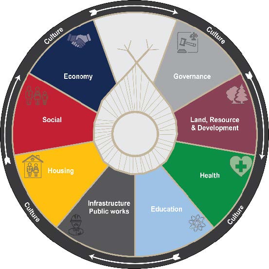
Community feedback collected through the various forms of engagement helped to create the guiding goals and actions included in this section of the Plan. Based on the input of LLRIB members, a planning wheel was developed that includes eight priority areas all surrounded by the theme of culture. For each theme, background information, data, and community goals are provided.
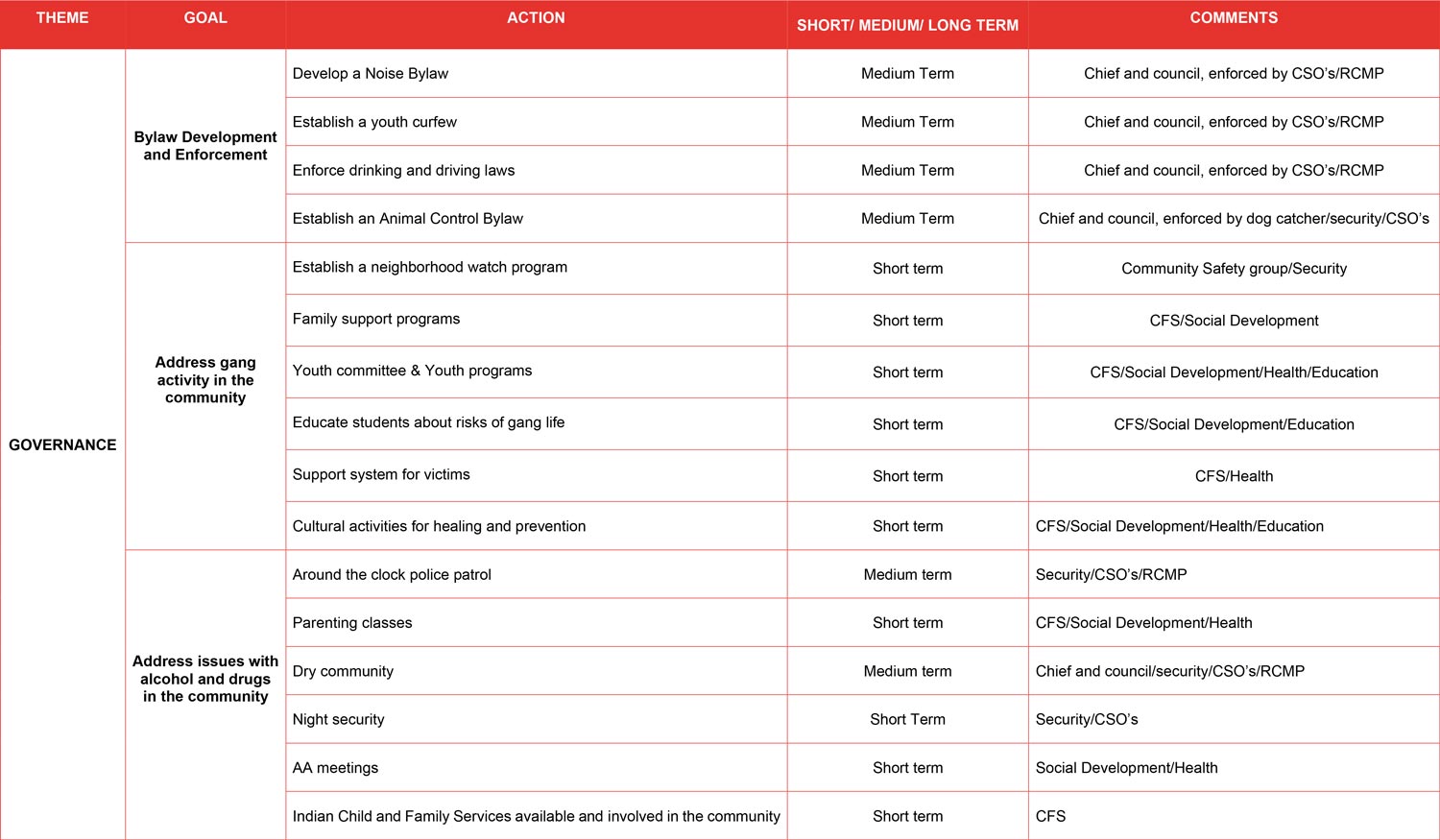
GOVERNANCE
LLRIB leadership consists of 12 Council members and one Chief governed under a Custom Electoral system that requires an election be held every three years The Chief and Council is the elected government of the LLRIB. Their function is to provide good government for the Band by implementing by-laws and policies, carrying out strategic planning, ensuring fiscal management and monitoring the overall band operations. The Chief and Council have delegated the day-to-day administration of Band programs to its only employee, the Executive Director. This position in turn is responsible for supervising for Program Directors, who are then responsible for to the Band’s public/civil servants within their departments.
In order to provide the necessary administrative and financial support to the programs delivered by the Chief and Council, an administrative infrastructure has been established. The main administration branch for the communities for La Ronge, Sucker River and Hall Lake are in the Central Office in La Ronge.
The 2012 Community Plan outlined the following action and commitments for the area of Governance:
Action Area: Open Communication, Governance, and Leadership
LLRIB Commitments:
- Organize, come together, and participate in regular community and Band-wide meetings, events, and
- Provide welcoming, safe, and supportive environments for all Band members to participate and share ideas about the future of LLRIB.
- Improve communication within and among LLRIB’s member communities
Images from https://kitsaki.com/
Community Goals
Bylaw Development and Enforcement
- Develop a Noise Bylaw
- Establish a youth curfew
- Enforce drinking and driving laws
- Establish an Animal Control Bylaw
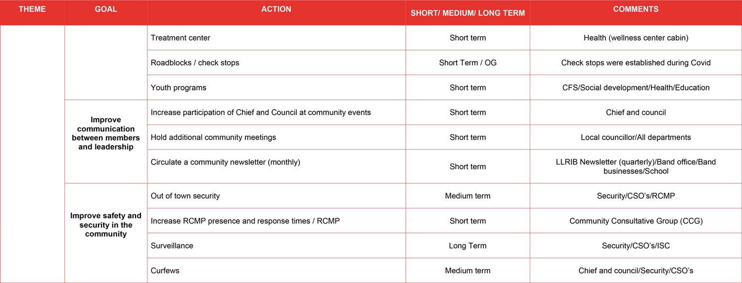
Improve communication between members and leadership
- Increase participation of Chief and Council at community events
- Hold additional community meetings
- Circulate a community newsletter (monthly)
Address gang activity in the community
- Establish a neighborhood watch program
- Family support programs
- Youth committee & Youth programs
- Educate students about risks of gang life
- Support system for victims
- Cultural activities for healing and prevention
Address issues with alcohol and drugs in the community
- Around the clock police patrol
- Parenting classes
- Dry community
- Night security
- AA meetings
- Indian Child and Family Services available and involved in the community
- Treatment center
- Roadblocks / check stops
- Youth programs
Improve safety and security in the community
- Out of town security
- Increase RCMP presence and response times
- Surveillance
- Curfews
Community Data
- Number of annual community meetings – 6 Meetings/Community Sessions
- Number of training sessions attended by staff – TBD
- Male: Female Ratio for Chief and Council – TBD
- First Nation election turnout – percent of eligible voters – TBD
- General Assessment Score – TBD
- Change in General Assessment Score – TBD
- Number of general band meetings held annually – TBD
- Average length of time served in role of Chief and Council members – TBD
Land, Resources & Environment
Background
The LLRIB Lands and Resource Office protects the traditional lands and traditional activities for LLRIB members. The Lands and Resource Office provides services for the leadership, administration, and membership.
LLRIB members. The Lands and Resource Office provides services for the leadership, administration, and membership. The Lands and Resource Office is committed to the ensure aspects of the “Duty to Consult and Accommodate” are being met with government, business, and industry.
LLRIB Lands and Resource Office Mission:
The mission of the LLRIB Lands and Resource Management Board is to ensure the meaningful engagement of LLRIB in all decisions surrounding Resource Development and Land Use in LLRIB Traditional and Shared Territory with the objective of balancing sustainable economic diversification, environmental health and sustainable traditional use by LLRIB Band Members in keeping with the values of our ancestors and our history as Treaty peoples, for the benefit of present and future generations of LLRIB members.
LLRIB is a multi-reserve Band with 19 reserve lands which amount to 210,003.5 hectares. They include:
- Bittern Lake 218 – 6,886 hectares
- Four Portages 157C – 20 hectares
- Fox Point 157D – 70 hectares
- Fox Point 157E – 20
- Grandmother’s Bay 219 – 4,488.90 hectares
- Kiskinwuhumatowin – 90 hectares
- Kitsakie 156B – 74 hectares
- Lac La Ronge 156 – 40 hectares
- Little Hills 158 – 20 hectares
- Little Hills 158A – 30 hectares
- Little Hills 158B – 20 hectares
- Little Red River 106C – 12,939.30 hectares
- Little Red River 106D – 2,590 hectares
- Morin Lake 217 – 14,146.10 hectares
- Old Fort 157B – 40 hectares
- Potato River 156A – 50 hectares
- Stanley 157 – 30 hectares
- Stanley 157A – 8 hectares
- Sucker River 156C – 80 hectares
Culturally Significant Areas
- Portage routes
- Berry patches
- Mushroom picking areas
- Wild rice areas
Community Goals
Protect the Environment
- Address litter and garbage throughout the community
- Establish forest fire management plan
- Remove dead trees surrounding community to reduce forest fire risks
- Remediate old dump site
- Remediate old store site
- Protect the lakes and water sources from contamination
- Practice responsible clear cutting and logging to preserve treed areas
- Practice responsible resource extraction
Protect Traditional and Historic Sites
- Churchill River system
- Hunting, fishing, and trapping areas
- Grave sites
- Protect chimney at the old site
- Little Hills
- Church
- Cheapugumikohketc
Community Data
- Population density – TBD
- Land acquired through land claims – TBD
- Number of Urban Reserves Created – TBD
- Active number of leases – TBD
- Active number of permits – TBD
Health
Background
Lac La Ronge Indian Band Health Services Inc. promotes healthy communities for the well-being of all community members in the communities of La Ronge, Sucker River, Hall Lake, Grandmother’s Bay and Little Red Reserve.
The LLRIB Health provides these programs and services:
- Prevention and recovery
- Mental Health
- Indian Residential School
- Suicide Prevention
- Family Violence & Crisis Counselling
- Cultural Support
- MMIWG
- Medical Transportation
- Fetal Alcohol Spectrum
- Long Term Care
- Wawhtwikumik Group Home
- Administration
- Public Health Nursing
- Water quality control
- Sexual Transmitted Disease
- Dental Health
- Prenatal/Maternal Health
- Health Education
- Youth Wellness
- Home Care Services
- Diabetes Nursing
- CHR Support
- Emergency Response Coordination
- Jordan’s Principle Support
LLRIB Health Mission:
The Lac La Ronge Indian Band Health Services will provide quality and efficient programming which is equitable and accessible while supporting and ensuring the holistic wellbeing of all band members in each of our communities.
LLRIB Health Vision
The five (5) communities we serve will work together to promote and enhance healthy lifestyles by ensuring accessible and quality health services.
The 2012 Community Plan outlined the following action and commitments for the area of Health:
Action Area 4: Promote Recreation and Wellness
LLRIB Commitments:
- Provide a variety of recreational programs that suit a wide range of interests, skill levels, and age
- Improve the physical structure and organization of each community to ensure fun and recreation become part of a daily routine.
- Focus on greater community involvement and
Community Goals
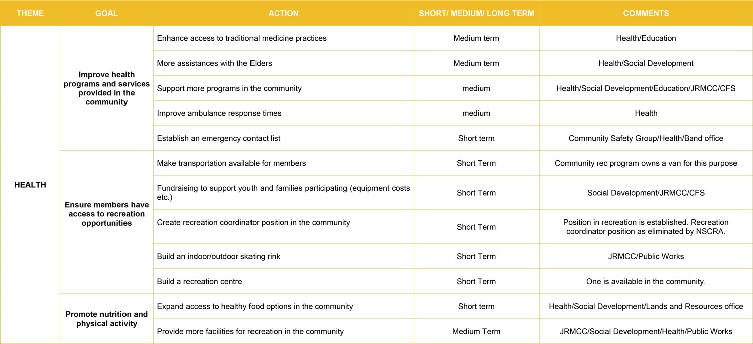
Improve health programs and services provided in the community
- Enhance access to traditional medicine practices
- More assistances with the Elders
- Support more programs in the community
- Improve ambulance response times
- Establish an emergency contact list
Ensure members have access to recreation opportunities
- Make transportation available for members
- Fundraising to support youth and families participating (equipment costs etc.)
- Create recreation coordinator position in the community
- Build an indoor/outdoor skating rink
- Build a recreation centre
Promote nutrition and physical activity
- Expand access to healthy food options in the community
- Provide more facilities for recreation in the community
Community Data
- Number of diabetics – TBD
- Mortality rate – TBD
- Immunization rate – TBD
- Number of health clinic visits – TBD
- Tenure of Health Services Staff – TBD
- Number of ambulance / medical taxi / fly outs – TBD
- Number of first responders in community – TBD
EDUCATION
Background
Sally Ross School provides education in the community of Hall Lake There are professional staff,
support staff and paraprofessional staff. Sally Ross School first opened in 1984. In 1995 -96 a gym, computer lab/library and classroom additions were buit onto the school. It is now a kindergarten to Grade 12 School. The School consists of 12 classrooms and a computer lab, special education resource room, behavior classroom, Cree classroom and library. For recreation we have a gymnasium, playground, soccer/baseball field, basketball/tennis court, hockey rink and ski trails.
Sally Ross School is dedicated to Sally Ross and is named in her memory. Sally Ross an early leader in education was born in the area on March 3, 1888. She commenced her formal education by enrolling in Emmanuel College in the Prince Albert area in the 1900s’. Sally Ross lived in the Hall Lake area from time to time as well as in the La Ronge and Little Hills areas. Throughout her lifetime, she placed a high value on education and was one of the true leaders in earlier times. Many of her relatives still reside in Hall Lake and the La Ronge areas.
Lac La Ronge Indian Band Education – Vision:
The education of our children is based on the culture, values, skills, and pride of the Lac La Ronge Indian Band. Educational activities reflecting Woodland Cree culture and Cree language are to be integrated into the provincial curricula to provide the educational foundation from which the individual student can learn to live successfully and happily in any society. By providing educational experiences that interconnect the child’s community, Cree language, history, and culture, the provincial curricula, and the world at large, our children will acquire the skills, knowledge, and strength to enable them to assume productive roles as adults.
Lac La Ronge Indian Band Education – Mission Statement:
The Lac La Ronge Indian Band, N-12 Education Program will provide an education that meets the unique needs of our children; that emphasizes the four goals of pride, culture, skills, and values; and that helps our children achieve academic excellence and proficiency with the Cree Language. The Lac La Ronge Indian Band, Post Secondary and Adult Training Program will provide support to Lac La Ronge Indian Band members to gain access to post secondary education, training, and employment opportunities to attain the qualifications, skills and experience needed to pursue individual careers which will further contribute to effective Band government and economic self reliance.
LLRIB Education Department Goals:
- To provide a consistent educational program for all students within the
- To implement and maintain educational programs that meet the unique needs of our
- To provide educational programs that provide opportunities for all our students to learn and develop knowledge and skills needed to successfully participate in society, whether on or off reserve.
- To provide educational programs that will develop pride in our
- To provide educational programs that promote and upholds the traditional values of the members of the Lac La Ronge Indian Band.
- To provide a programs and levels of service that are equal to the standards prescribed for education within the province of Saskatchewan.
- To provide educational programs that involves elders, parents and other community
Community Goals
Enhance adult education programs and services for adults
- Establish an adult employment training centre
- Purchase computers for the school / establish community computer lab
- Improve internet access for online courses
- Provide land-based learning and instruction
- Provide parenting programs
- Offer Adult Basic Education Certificate Program
- Offer General Educational Development Course
- Provide safety training courses
- Provide First Aid / CPR training
- Provide childcare services for adult students
Community Data
- Population on-reserve with a post-secondary certificate, diploma or degree – TBD
- High school graduation rate on-reserve –
- Students funded by post-secondary program –
- Graduation rate for Post Secondary Education
- Waiting list for post-secondary program –
- Grade 12 graduates that attended post- secondary school –
- Certificates last 5 years -TBD
- Diplomas last 5 years – TBD
- Degrees last 5 years – TBD
- Masters last 5 years – TBD
INFRASTRUCTURE / PUBLIC WORKS
Background
Water
Hall Lake operates a water treatment plant that provides water for all houses on-reserve. Water is piped to all community buildings and homes except for two older homes that receive water via transport trucks.
Sewage
All homes except for a small number are connected to the central sewer system. Two pump stations transport sewage to the lagoon, located just off of the reserve.
Basic Services
All houses on reserve are connected to natural gas and electricity and receive garbage collection service. Garbage is picked up by truck and hauled to a landfill.
Community Facilities:
- Indian Child & Family Services
- Sally Ross School (N-12)
- Charlie Halkett Memorial Band Hall
- John Ross Clinic
- Elders’ Home
- Youth Centre
- Community Store
- Recreation Hall
- Church
- Teacherage
- Sports Fields
- Sports & Cultural Grounds
- Outdoor Ice Rink
- Baseball Diamond
- Community Gardens
- Fire Hall
- Head Start
- Medical Transport
- Cross-country Ski Trails
- Gas Station activities
The 2012 Community Plan outlined the following action and commitments for the area of Infrastructure:
Action Area 6: Build Connections
LLRIB Commitments:
- Enhance and build new infrastructure to ensure direct, safe, and accessible routes to important destinations within and between each community.
- Develop creative and affordable transportation options for residents to travel within and between each
- Create gathering spaces that will link communities and people
Community Goals
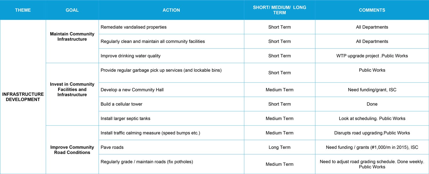
Maintain Community Infrastructure
- Remediate vandalised properties
- Regularly clean and maintain all community facilities
- Improve drinking water quality
Invest in Community Facilities and Infrastructure
- Provide regular garbage pick up services (and lockable bins)
- Develop a new Community Hall
- Build a cellular tower
- Install larger septic tanks
Improve community road conditions
- Install traffic calming measure (speed bumps )
- Pave roads
- Regularly grade / maintain roads (fix potholes)
Housing
Background
LLRIB HOUSING MISSION STATEMENT
To improve the living conditions of all Members by providing Members with access to affordable housing that meets all health and safety standards through an orderly and regulated housing delivery system that is fair and equitable for all Members and by ensuring that the existing Housing Stock is maintained.
LLRIB HOUSING GOALS
Housing Department aims to fulfil the following housing goals for its Members:
- To build and provide access to safe, affordable and energy efficient housing that meets applicable building standards
- To develop and administer a maintenance program to ensure minimum levels of health and safety are met
- To extend the useful life of the Band’s existing Housing Stock
- To promote homeownership on LLRIB Land
The Housing Department manages Band rental units, INAC (non-rental) units, duplexes, 4-plexes and apartments. Housing applies annually for the funding of new housing projects and coordinates the construction with contractors, trades, utility companies and suppliers.
The 2012 Community Plan outlined the following action and commitments for the area of Housing:
Action Area 3: Re-Invent Housing LLRIB Commitments:
- Design and build housing that responds to local needs and
- See every housing project as a way to use and develop local resources (existing infrastructure, material, skills, knowledge, etc.).
- Build community pride in housing through innovation
Community Goals
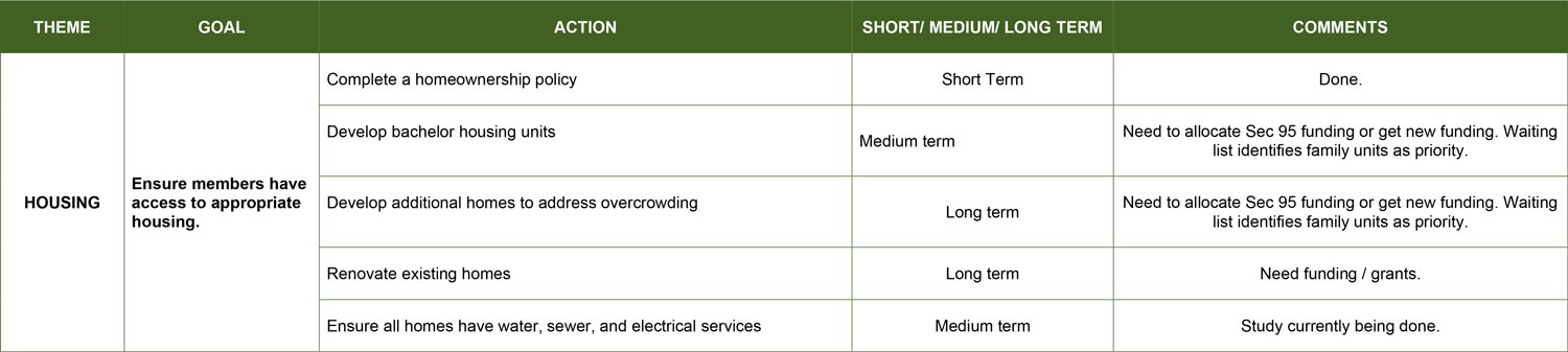
Ensure members have access to appropriate housing.
- Complete a homeownership policy
- Develop bachelor housing units
- Develop additional homes to address overcrowding
- Renovate existing homes
- Ensure all homes have water, sewer, and electrical services
Community Data
- Housing wait list –
- Number of dwelling units on-reserve –
- Average persons per household on-reserve –
- Percent of dwellings that are crowded – TBD
- Percent of dwellings that are in adequate condition – TBD
- Percent of on-reserve dwellings that require major renovations – TBD
- Percent of dwellings that need replacement – TBD
- New dwellings constructed in past three years – TBD
- Number of empty lots ready for development – TBD
- Number of housing units for community staff (i.e. teachers, CFS, RCMP, nurses, ) – TBD
Social
Background
The LLRIB Social Development Department provides services and resources to individuals who reside on reserve and are unable to meet their basic needs. The department also provides Pre-Employment Supports (PES) programming. The PES program aims at increasing an Income Assistance client’s employability by addressing barriers to employment. PES provides client supports specific to the individual client, within a service delivery case management model. PES Caseworkers provide individualized assessments and develop Mandatory Action Plans that will identify how a client plans to remove barriers to employment and develop the necessary skills and enter educational programs that lead to training and employment (AANDC, 2014). The following are some possible services and programming that PES may offer in order to increase their clients’ employability:
- Literacy Courses
- Budgeting
- Work Skills Training
- Safety Ticket Training
- Driver’s Education
- GED/ABE
- Obtaining Identification Cards
- Work Experience
- Life Skills Training
The Band Membership is also under Social Development, membership is maintained by the Membership Officer. The Band Membership Officer records all events (births, deaths, marriages, divorces, miscellaneous amendments, forced age of majority) to Indigenous Services Canada for the Indian Registry, including transfer requests in and out of the LLRIB. The Membership Officer reports to Chief and Council regularly to update the population statistics and events reported. Indian Status Cards are issued from this office to Band members and to other person(s) applying from other Bands across Canada. Population statistics are completed yearly. The Membership Officer also assists LLRIB Members only in completing assorted forms/ applications.
LLRIB Restorative Justice Program
LLRIB provides a Restorative Justice Program with mediation services delivered by aboriginal people in La Ronge for youth and adults who come into conflict with the law. The mediator attempts to bring people and resources together, so that the harm caused by the offence can be repaired. Agreements often involve community healing, compensation and emotional closure. The Restorative Justice Program service area’s include La Ronge, Hall Lake, Sucker River, Grandmother’s Bay and Pine House.
LLRIB Child and Family Services
In March 1994, the Minister of Social Services, now the Ministry of Social Services, announced that a Tripartite service agreement had been signed with Chief & Council of the LLRIB and Lac La Ronge Child and Family Services Agency Inc. This agreement authorized Lac La Ronge Indian Band Child & Family Services Agency to take direct operational responsibility, for the delivery of child and family services, to the band members in the six LLRIB communities.
The ICFS Agency is responsible for the administration and operation of the following services and programs, subject to the legislation of The Child & Family Services Act for the Province of Saskatchewan and the ICFS Agency Policy & Procedures:
- Child Protection Services
- Foster Care Services
- Professional Management and Staff
- Public Awareness and Education
- Training in Human Resource Development
- Program Evaluation
- Family Support Services
- Preventative Services
- Child and Youth Services
The 2012 Community Plan outlined the following action and commitments for the area of Youth (social development):
Action Area 5: Empower Youth LLRIB Commitments:
- Develop a variety of inclusive and ongoing activities, programs, and events that will build and enhance skills and knowledge and encourage creativity.
- Provide safe, nurturing, and secure places for youth to gather, learn, and have
- Enable and encourage parental involvement and support regarding their children’s well-
Community Goals
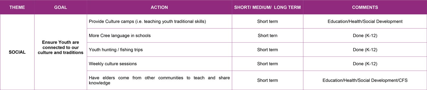
Ensure Youth are connected to our culture and traditions
- Provide Culture camps (i.e. teaching youth traditional skills)
- More Cree language in schools
- Youth hunting / fishing trips
- Weekly culture sessions
- Have elders come from other communities to teach and share knowledge
Community Data
- Adult correctional services, custodial admissions in Saskatchewan by Aboriginal identity –
- Number of homicide victims –
- Missing and murdered indigenous women and men –
- Men/women victims of spousal abuse –
- Number of Income Assistance Clients –
- Number of suicides per year –
- Number of community of events per year –
- List of volunteer boards, committees, etc.
Economy
Background
Lac La Ronge is the service centre of the LLRIB, supporting a substantial number of local Band member run businesses and providing a central location for public services and administration.
Keethanow Group of Businesses central office is located at La Ronge Band Office and administers the businesses for the communities of Sucker River, La Ronge, and Hall Lake. The Goal of Keethanow Group of Business is to provide retail for Northern Saskatchewan and employment opportunities for LLRIB Members. The businesses currently operating in the Keethanow Group of Businesses include:
- Keethanow Food Supermarket
- Keethanow Lumber and Furniture
- Keethanow Gas Bar
- Keethanow Bingo North
- Sucker River Community Store
- Hall Lake Gas Bar
- Bells Point Corner Confectionery
Additionally, Kitsaki Management Limited Partnership (KMLP) is a privately owned corporation run by a Board of Directors made up of LLRIB Chief and Council. KMLP’s mission is to promote job creation for Band Members and provide opportunities for training and skill development by investing in a variety of private businesses, funding community development and sponsoring student scholarships. With its head office in Lac La Ronge and administrative office in Saskatoon, KMLP employs more than 600 people including 100 Band Members and manages a portfolio of diverse companies including:
- Athabasca Catering Limited Partnership
- Canada North Environmental Services Limited Partnership
- First Nations Insurance Services Limited Partnership
- Kitsaki Procon Joint Venture
- Kitsaki Vegetation Services Limited Partnership
- Northern Resource Trucking Limited Partnership
- March Consulting Associates
The 2012 Community Plan outlined the following action and commitments for the area of the Economy:
Action Area 1: Capitalize on Our Assets to Stimulate Entrepreneurship LLRIB Commitments:
- Increase and support skill development and education opportunities for all
- Foster exploration and entrepreneurship that builds on the unique strengths of the
- Develop more opportunities for all six communities as well as off-reserve members to work together to develop innovative Band-wide projects.
Community Goals
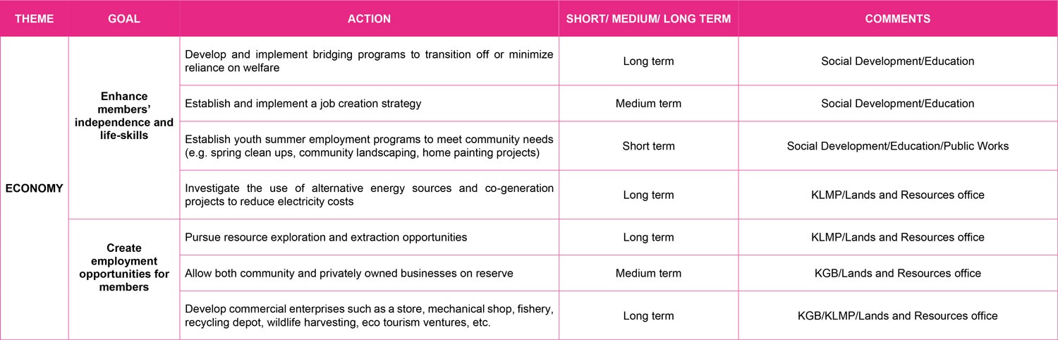
Enhance members’ independence and life-skills
- Develop and implement bridging programs to transition off or minimize reliance on welfare
- Establish and implement a job creation strategy
- Establish youth summer employment programs to meet community needs (e.g. spring clean
- Investigate the use of alternative energy sources and co-generation projects to reduce electricity costs
Create employment opportunities for members in the community
- Pursue resource exploration and extraction opportunities
- Allow both community and privately owned businesses on reserve
- Develop commercial enterprises such as a store, mechanical shop, fishery, recycling depot, wildlife harvesting, eco tourism ventures, etc.
Community Data
- Income assistance dependency rate – TBD
- Employment rate – TBD
- Employment growth – TBD
- Percentage of employed individuals working full time – TBD
- Average employment income for full-time full year workers – TBD
- Percent of self-employment income – TBD
- Own source revenue as share of government revenues – TBD
- List of economic development policies and procedures – TBD
- Average commuting distance to work – TBD
- Economic leakage – TBD
4 Community Action
4.1 How to Use This Plan
The CDP is everyone’s plan. We all have roles implementing it. The following are some examples of what community members, champions, Chief and Council, and community staff will do.
Community members will:
- Contribute strategies based on individual passions and strengths
- Participate in activities and events that bring the vision alive
- Commit to be informed, provide input and share with family
- Honour the work that has been done
Champions will:
- Provide advice and encouragement to help develop a detailed plan for each theme
- Hold knowledge in that topic area
- Connect and encourage community members to participate in plan implementation
- Meet with other champions to share information, coordinate among themes, and review progress toward the vision
- Identify and mentor potential future champions
Chief & Council will:
- Champion the plan, and each theme within it
- Approve, implement, and report on the plan
- Work with champions related to the various Council portfolios
- Liaise with and lobby other organizations and governments
Community Staff will:
- Use the plan objectives as a guide for ongoing work and development of proposals for new initiatives and funding
- Engage and facilitate community members and Champions to develop plans for each theme
Overall, we will:
- Empower ourselves and each other; we are all leaders, with opportunities to take initiative
- Think proactively, when you sense something coming, consider what needs doing and how you can contribute to a proactive response
- Cooperate in teams, working and playing together creates opportunities for synergy, learning,
- mutual support and fun
- Use our values and principles: remembering who we are, what is important to us, and how we work together will help us succeed
- Keep it positive: be constructive, building on individual strengths and community assets;
- Treat conflict as an opportunity for learning: practice compassion and reflective listening when we have disagreements
- Celebrate and recognize achievements: honour the contributions of individuals and teams toward our success in implementing the plan.
- Add new community reports to the master copy of this CCP, which will ensure a ‘library’ of documents is maintained and available for leadership and various departments to review
4.2 Monitoring, Evaluating, and Updating this Plan
The CDP is intended to be a living document. This means it will be monitored and updated as community priorities evolve.
Monitoring
We will document activities and achievements that contribute to the plan and its implementation on an ongoing basis. Once a year, we will celebrate what we have accomplished together. Recognition of steps towards that visions, both small and large, will help energize us to keep moving forward. We will repost on progress annually, using this plan as a guide for communicating about what has been done and how.
Evaluating
We will assess the process and results of plan implementation every 5 years, or more often if needed. The Executive Director will ensure that the evaluation of progress toward implementing the Community Strategic plan occurs in a timely and inclusive way. Champions and staff will carry out the evaluations and engage interested community members.
Updating
We will review our visions, values, principles, goals and objectives following each evaluation of progress toward plan implementation (every 5 years, or more often as needed). We will update the CCP based on community needs and priorities identified through community engagement. This updating will help up make sure we continue to grow and evolve as a community. We must remain willing and able to respond to changes in the world, taking advantage of emerging opportunities and addressing external challenges.
4.3 Implementation Table
There are many identified actions and projects the community would like to undertake as a result of this Community Development Plan. This information is illustrated in the Implementation Table which summarizes community priority areas, describes their relative importance, and identifies what resources are required. The Implementation Table should be referred to and updated often as projects are completed and priorities change.
The Implementation Table, along with information within this document, should be used when applying for grants and/or project funding opportunities. This ensures leadership, various departments, and community organizations are working towards the same goals.